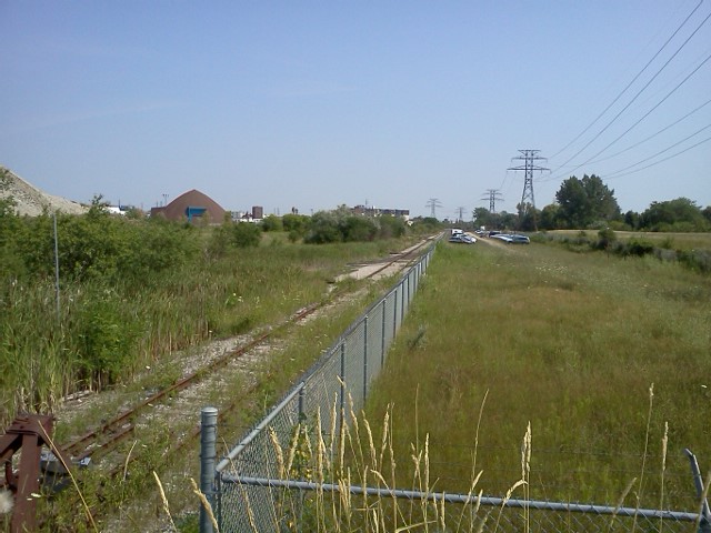
Showing posts with label Canadian National. Show all posts

Tuesday, 6 September 2016

Crossing the Causeway

Still here, finishing my reno work, running when I can.  My training sucks right now.  Didn't have much time to even get vids or pics since my weekends had to be spent elsewhere.

My wife pulled a set of prints from a Black's envelope from 1987 when we made a trip down east to Cape Breton for Christmas visit.  Long since forgotten that we drove to the Canso Causeway and happened upon some CN freight making it's way from the line from Port Hawksbury and on to mainland Nova Scotia.

The train was lead by a foursome of MLW 420s, all with CN 'Zebra Stripe' paint scheme as per the early 90s.  The lead was number 3550, then 3569, 3564 and finally 3541.  A long gone caboose followed in tow.


A later trip to the North Sydney ferry terminal had a MLW RS18 unit doing some service, number 3656.


Really just adding these to the on-line collection.

Thursday, 25 April 2013

Bright mornings, fast trains and some poking around

I haven't had much time to be out taking images of trains lately.  There is a bridge under repair that connects my local area of Taylor Creek with Sunnybrook and it's throughly fenced in until the workers have completed their tasks.  If you're familiar with the area, it's the bailey bridge that crosses the CN Bala tracks near Don Mills Road.  The area has been undergoing renovations to replace the aging footbridge under Don Mills.  That work is completed and now they are doing the decking on the bailey bridge.  Before the bridge closure you could still navigate across Don Mills but a deckless bridge isn't very useful.  Most people are just going around the fencing and cross the tracks but I have this inate refusal to tresspass on the Metrolinx right of way so I'm staying away from the area until the work is done.

Bala below Doncaster sees not a lot of CN action these days.  VIA's Canadian #2 still uses it and Richmond Hill GO service on weekdays, but I haven't seen freight action there in months.  CP's Belleville and North Toronto subs are my freight train sources these days.  The bridge work at Don Mills makes this less accessible for the time being.  I can still get around through the area near Cottonwood Flats if I have time for longer runs.  The level CP crossing at Wicksteed needs only 25 minutes for me to get there with the bridge open, but over an hour with the bridge out.  Summerhill is more accessible right now and Summerhill has better viewing, albeit not at track level.  I did try a few longer shots of the Leaside yard area from Cottonwood Flats but there are just too many trees in the way.

The reliable Kingston sub is always nearby.  6:30AM and on that is one busy line.  Mutliple GO trains an hour, plenty of VIA trains coming in and going out.  Being wakey wakey with the ever earlier sun shining in through the window and the window opened a crack for air, the Lakeshore line gets mighty noisy.  This morning I headed down Woodbine Avenue to the crossing north of Gerard Street just in time to catch VIA combo 50/52 heading to Ottawa and Montreal with it's unique two train tandem.

Blink and you'll miss it:


They don't have the high-speed train warning signs posted everywhere on that line for nothing.

While scoping out some other locations on the streets nearby I'm glad I had the camera rolling here for this GO eastbound unit:


Not the best location, it was over a fence at the base of Westlake Avenue just south of the Danforth, but it was a unique catch.  This double-ender had two of GOs refurbished F59PH units, #564 up front and #563 tacked onto the rear.  These 59s have to double up to meet the performance demands of 10 car passenger service as they lack the oomph of the MP40PH 4000HP powerhouses on most of GOs trains.

Monday, 11 February 2013

VIA Canadian doesn't quite fit - Google maps

Check this out, it's a location link in Google maps.  Zoom a notch and pan after you open it.

https://maps.google.ca/maps?hl=en&ll=43.644515,-79.380346&spn=0.002935,0.004823&t=h&z=17

This is Union Station in Toronto.  The train that juts out the east and west ends of the platform appears to be the VIA Canadian, the giveaway being the observation dome on the tapered end car on the east (right) side.  A pair of engines, the first car and part of the second car protrude the west side while the trailing 3 cars and part of the 4th protrude the east side.  Obviously too long for the platform, I guess to board and de-board, either shunt the cars to position in stages or everyone passes through to the platform adjacent cars.

I'd never noticed it before in the maps.  Neat.

Monday, 14 January 2013

A warm midwinter weekend

Too nice to hang about this weekend.  It's not often we get temps in the teens in January. Getting them for a full weekend makes you wonder what you did to deserve it.  Shorts on, a couple of t shirts and out the door to catch some Kingston sub action.

Saturday was dropping by nearby Danforth GO station, enjoying the sunshine and catch what I could.  I headed out to try and catch VIA 60 as it passed through Danforth and got there just in time to miss it.  I did get a few seconds of it's rear end disappearing to the east.  Some bits of a couple of scheduled GO units had to suffice.

I did grab a couple more segments at a section on Eastwood Avenue thats pretty close to to rails but hard to get good position.  The southern track is so close to the ROW fencing that eastbound units seem like they're going to roll right over you.  The houses nearby must have their dishes glued down just in case.

I returned to Danforth a little after noon to see what else may come by.  I noticed the signals on the north and centre tracks switched from yellow to red while standing on the bridge.  The north track would be the scheduled westbound GO.  The centre track would be VIA, but I wasn't sure which one.  Later checking it was VIA 643 Kingston/Toronto.  The GO had already passed, the VIA came by 10 minutes later.


On Sunday I headed out to an area just off St. Clair Avenue E and Midland Avenue, a little N/E of Scarborough GO station and see if it offered a decent viewing location.  It rained all night but by morning had moved off to the east leaving just a hazy day behind so no problems taking the new Sony along.

I scoped some sections along a street adjacent to the tracks called National Street.  The hillside leaves the ROW fencing well below the viewing angle, although a bit steep and hard to get a good footing.  Also, lots of trees planted to offer some separation from the tracks for the nearby new housing development making some spots more obscured than others.  At the north end of the street the view of Kingston sub to the north east is nice and unubstructed although the property beyond the roadway is CN owned.  No need to step into the field though, the view simply standing at the end of the street is as good as it gets.

First came VIA train #60 out of the southwest.  The heavy haze carried the unmistakable roar of a locomotive from well down the tracks.  The haze also gave it neat effect of the lights piercing through as the train powered it's way through Scarborough GO station and along the long straightaway until it bends to Brimley.  Lead loco was P42DC VIA 919.  I shot it from the embankment in a slightly flattened area with decent footing an no tree or fencing in the way of the shot.


Next up, I headed to the north end of the street to catch an eastbound GO unit reversing it's way toward Union Station, nothing particularly interesting and I failed to have the Sony on as it appeared around the corner so we'll leave that vid in the archives.

For the last I waited for the eastbound GO which would be a few minutes after the w/bound unit.  Staying in position at the north end of National, I picked up the lead loco as it passes on the southern track and appearing through the trees of the embankment.  As it passed and I switched to the N/E view I noticed the lead loco was not alone, with an older EMD slotted in second place.  The second unit was 558, an F59PH.  A quick lookup in google and youtube shows a few other hits for this locomotive for the past couple of years.  Not sure if it has been in continuous service or temporarily retired but it was a surprising catch nonetheless!


Trails were too messy to run this weekend with the snow melt and the rain.  Kingston sub is never far away for a street run, always manages to deliver and even the occasional surprise can be had.

Friday, 23 November 2012

Ghosts of Raillines Past - CNoR / Taylor Creek

Earlier in the summer I was doing some surfing for information on the old Canadian Northern Railway.  This was mainly inspired by the recent conversion of the CNoR locomotive works building in Leaside into a Longos grocery store.  It's a pretty cool looking building if you haven't seen it yet, both inside and out.  It's hard to imagine that this century old structure was used to service railway engines of the day.  Despite the loss of CNoR and it's ultimate encapsulation into today's Canadian National Railway, the building survived under a few different industries until sitting idle behind a group of buildings along Laird Avenue.  Most people (me included) never laid eyes on the structure until some businesses along Laird were removed, exposing the building's facade to passing traffic.

Along the way I found this site with images from the Global TV helicopter  showing a series of overhead views of the east Toronto area and a few key images of East York.  I was guided to the site by a hit on one of the comments regarding the second image showing Taylor Creek.  Taylor Creek is my bread and butter for running since it's literally steps away from my house.  I run the higher south side trail frequently, known to a few as the Taylor Creek harrier circuit, since it's soft and fairly flat for the most part albeit a bit swampy in places.

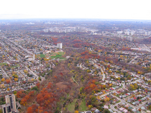
This image on the site shows Taylor Creek (the image is captioned Looking northwest up Glen Stuart Ravine on the page) along the section east of the baseball diamonds in Stan Wadlow park.  If you look along the left side of the valley you will see a long straight line leading up to the diamonds.  From there it veers a bit left and continues on towards the lower Don Valley at Don Mills Road.  This was part of the CNoR Toronto-Ottawa railline.  I've often thought this had to have been a railline at some point given the sheer straightness of this mainly level trail.

Hard to pass up an opportunity to explore a railline that once passed only a few hundred meters away from my house.  With that, it was doing some searching of maps, aerial images and whatever I could find, wait for the leaves to fall away, then go on a hunt.

It starts with a whopping 3 minute jog down hill to the base of Haldon Avenue.  Standing on Haldon in line, the ROW would be roughly where the hydro lines are.


 Following the line of the eastbound trail the rails would have passed through where the roadway ends and the parking lot begins.  Hydro One towers run the full length of the trail in both directions.


Utility poles just north of the pathway on the east section may be the current incarnations of those used by the CNoR at the time, being reused and replaced over the years.  Previously the poles used to terminate at a hydro substation just beyond the parking lot.


Further east is much the same until you reach a hydro station past Main Avenue.  From Google aerial maps you can see the line stretching through the valley and detect the segment between Dawes Road and Victoria Park Avenue just south of Massey Square and continue on to what is now the TTC line out of Vic Park station.

Returning back to Haldon Avenue, growth makes the immediate west part inaccessible for a bit


and today it's a slightly muddy climb under the O'Connor bridge to connect back to the ROW area.


The trail runs high on the north side of the ROW and you can see where the railbed would have existed lower on the south side.

 It's pretty swampy down there and must have presented some challenges in keeping the railbed dry and intact.  As you progress westward you descend a sharp hill and soon are back onto the old ROW.
It also gets pretty swampy on some of the higher parts of the old right-of-way.

At the northwest end of the trail, the ROW would have crossed part of what is now a parking lot and extended into the web of on and off ramps around the DVP and Don Mills Road.  Anything that existed along there is long gone with major regrading and reworking for the DVP.
Next is looking up archival aerial views on the City of Toronto  Archives site.  These particular images are from 1942, well after the rails were pulled up but the right-of-way can be easily seen.  You will need an SID reader for the files downloaded from the archive site.  Compare it to either Google maps or Bing maps, you can see that Don Mills Road was the same as it is now along with the sections of O'Connor Drive that form it's southern terminus.  Also pretty well intact is the Bala sub ROW.  The river itself has been rerouted to accomodate the DVP in some sections although you can see that the short curved section of the river that approaches the CN lines is still the same in the area where the CNoR line would have connected up.

From this aerial image, you can see the ROW extending from the Bala line to the river and what looks like supports for the bridge structure:


Here is the same location on Google, the image is a couple of years out of date:


The orientation of the images is slightly different.  The Google map has north directly up while the aerial image from 1942 has north a little to the right, more in line with the orientation of the street grid pattern.  There's a whitish section in the water that looks the same in both images and lines up with the rail ROW.

On Sunday, with warm temperatures and growth dying off, I was able to climb around the area of the hydro tower that appears near the center of the Google image above.  Directly adjacent to the hydro tower is this structure covered in weeds and vines:


It sure looks like a bridge support to me.  In the 1942 image there's several industrial buildings just south of this spot but they don't appear to be where this structure lies.

On the opposite side of the river is the large angular whitish object that appears in the water in both the 1942 image and the Google image.  It's just a rocky outcropping that's accessible from a trail that runs on the north side of the river.


This is the same outcropping from the other side:


I poked around but could find no sign of any bridge structure.  The overgrowth is very heavy though:


What is obvious on the other side is the raised railbed built up to level the tracks for merging:


When you stand here, you can see the bed leading from where the bridge abutment would have been and it's path into the Bala tracks.

So, not much of this line remains beyond this bridge structure, the level graded areas in the valley, the raised railbed areas and the legacy of the utility poles east of Haldon Avenue.  It's still fascinating to think of a steamer chugging it's way delicately through Taylor Creek on it's way east, or back.

Sunday, 28 October 2012

Nighttrain

At Pottery Road to try a little nighttime railfanning, mostly just a practice run.  I was hoping to catch a night passing of VIA's Canadian train #1 so a southbound unit near the schedule departure time of #1 had me a bit confused.  The unit numbers were unfortunately missed.


Admittedly, I'm not sure about exactly when the Canadian leaves Union Station or even which route it takes.  As it makes it's first stop in Washago it seems natural it would follow Bala the same way it uses it eastbound, since it would otherwise have to reverse or wye somehow to reach Washago on anything but Bala.  VIA schedule shows departure from Union at 10 PM, Saturday night.  This unit came through at 10:05.  I've seen it several times on arrival eastbound but never ventured to catch a westbound departure.

I did hang around a while to see if VIA would come through but it got progressively colder and less comfortable and I eventually gave up.  Consider this a consolation prize.

The Sony SX63 has it's limitations at night.  Autofocus isn't all that great and the manual focus is difficult to set and get it right since I have to use the touch panel.  Next time I'll prepare focus before venturing out.  Low light is okay, not the best but so much better than cameras I've used in the past.

Sunday, 16 September 2012

A Face Full of Train

Scooted down to Pottery Road to catch the ONR Northlander, as it's days are coming to an end.  Used the Nikon today to try for a few good snaps.  Would have been better had I realized the white balance was set to incandescent.  Post processed it get the colours decent anyway.


Next Sunday is it's last Sunday run.  I have a week to decide where to shoot from.  I have one Tuesday morning I can try as well depending on timing.

Saved the running for later in the day, at the Terry Fox Run (Wilket Creek), 3 1/2 miles to the venue, run 10k (up paced, not race effort), and 3 1/2 miles back for 13ish miles. Added a bit to make up for their short 10k loop as I wanted at least 13 today.

Saturday, 15 September 2012

Another VIA Canadian vid

I was heading over to Bayview Avenue to check out the area around the CP overpass after reading a bit of this web page on rudy.ca about Old Pottery Road.  I wanted to see if the area had any good viewing locations for the CP Belleville sub section that crosses this location.  After crossing along Pottery Road and heading up Bayview Avenue, I heard the crossing signals at Pottery go off.  I turned to catch the VIA Canadian train #2, but too far up the hill to make it back down in time to get a closer view.  It's still an interesting viewpoint, higher up the hill, and you can watch it wind it's away beside lower Bayview on it's way to Union Station.


As for Old Pottery Road, the area is under construction by Hydro One as they have been working on the new towers just south of the CP Rails, and views shown in Rudy's page above are not accessible at this point.  I suspect that once completed, any good viewing access that existed to the CP line will no longer be there.

Saturday, 18 August 2012

Ghosts of Raillines Past - The GECO / Kingston Extension

I saw a post somewhere that made mention of trains passing by the old Hy & Zel's in Warden Woods Mall and it sparked a memory for me at the same location. I remember sitting in the parking lot as a train headed south, my wife headed into the mall and I stayed back to watch a short consist go by.  I now recognise this rail line as part of the GECO branch line.  This section was built to form a loop for local switch traffic in nearby yards, connecting back to the very busy Kingston line.  It was closed in 1996 and Hy& Zel's, together with the rest of Warden Woods Mall, is now history.

A few weeks back I traced the existing active section of the GECO branch from Comstock to the Uxbridge sub.  This weekend I followed the path of the removed section to see what would remain 16 years later.

With Google maps, the rail bed can be traced fairly easily and the in between reclaimed sections are easy to interpolate from it's satellite view.  On foot, it's not so easy.  I cached the satellite view on my phone, grabbed the Sony cam too, just in case I met some traffic on the active lines, and went off towards the southern connection point.

I wound my way south to along the Danforth then east to Danforth Road.  Near Warden, I could hear a short unit, maybe engine(s) only, heading along the Kingston line but wasn't yet in position to catch it.  A bit later I found Milne Avenue near where the spur connected up with the Kingston line tracks.  An industrial building occupied the section just north of the switch and I wasn't about to enter to see if I could spot any remnant of the switch bed, with 'private property' sounds in abundance.

Edit: I found this image on Railpictures.ca from June, 1983. On the right side of the image is the building shown above. Note the railway crossing signal where the extension would have passed near the building. The first indication of the line is an asphalt patch on Milne Avenue left behind after rail removal.


At the north end of the patch is a short metal barrier added to prevent road traffic from accessing the road level bed.

The path of the rail bed is quite obvious here as it parallels Milne Avenue.  When you stand at this point you can see the path of the former railbed through the entire section.
It the crosses Mack Avenue with a similar patch in the asphalt.  At both former crossings can be seen the painted 'X' warnings on the roadway, this despite maybe 20+ years of wear.

North of Mack the patch guides the railbed into a dome shaped storage building.
With the path leading into closed industrial property, I was forced to head west and looped around to find the crossing point on Danforth Road.  Here, I had to resort to my cached map on my phone as finding the location was essentially impossible visually.  There was no sign of any former crossings, likely the roadway had since been resurfaced.  The only indication of the former line was the curvature of the property lines of the nearby buildings indicating they abutted to the right-of-way.
Maybe this road patch was part of the crossing, but I doubt it.  My maps indicated it was very close to the correct location but it didn`t seem to completely cross the road.  However, it`s possible that more patching simply fooled me.  Very difficult to say.  This lead to a roadway into a new housing development.  I followed the road until it was blocked and exited to some new but existing housing at Oates Drive

After running through a park north of Oates and passing a couple of standing water overflow ponds, I was now on Bell Estate Rd., a section thoroughly regraded and any hint of the former rail bed is long since removed.  Back to Warden I headed north.  A multi-business complex had an access area towards the back just south of a Hydro One station.  The area of the rail bed is somewhat obvious here, if you knew what you  were looking at.

It`s recessed along the back fences of some older existing housing of Santamonica Boulevard (yes, that`s what it`s called).  You can detect the climb from further south as you get here so the recessed grading was necessary for rail traffic.
I had no intent to wind my way behind the Hydro One station so instead headed back to Warden and then north to St. Clair Avenue.

At St. Clair, a trio of railway bridges cross overhead.

The western two bridges are for TTC line traffic.  The eastern bridge serviced this GECO branch section.
Climbing some stairs to Santamonica Blvd off St. Clair, you can cross along a field to track level and see the top of the bridge.


The rail ties are still in place, but no rail.  There still exists `no tresspassing' signs so it may still technically be trespassing to step onto the bridge, so I didn`t.  The TTC tracks into Warden Station are adjacent to the west side.


Back along the field, you can see more ties where the rails used to reside.  A TTC train is seen exiting Warden Station.


Southward, the rail bed disappears into the brush, heading on a downgrade.  I didn't venture down this way as the growth is pretty thick and leads back behind the Hydro One station.  I'd be interested to see how far the ties carry though without venturing too far, but not today.

While nothing large and mechanical may ever cross the GECO part of the bridge ever again, the other two bridges are perpetually active with TTC traffic, seen here as a TTC train crosses St. Clair.


I headed north through a park adjacent to the tracks, eventually returning to lower spur of the existing active GECO branch line extending from the Uxbridge subdivision.  This was seen in my previous GECO blog entry.

The immediate southern section has been regraded, making it impossible to locate any trace of the line.  A bit further south, adjacent to Pidgeon Street (clearly, they are running out of names for streets in T.O.), the line can be picked up through traces of right-of-way fencing and 'No Tresspassing' signage, the signs seemingly ludicrous given that nature has effectively reclaimed the entire area.


From Google maps, it does look traceable, although the late summer growth shown here makes naviging it next to impossible.  I may revisit this area sometime before next spring after the growth has died off and see what remains.

Of the whole spur section, the reminders of the track persist in the southern most section through the impact on the streets and housing.  The centre section is mostly reclaimed by industry and housing development.  In sections not regraded, the location of buildings and fencing hints at the CN ROW points.  Only in the nothern sections, especially around St. Clair Avenue, can the former railbed's infrastructure be seen and will likely be there for a very long time to come.

It was a fun run for a Saturday, about 90 minutes of running with an added hour for the shot taking.

Tuesday, 7 August 2012

Catching ONR 1800 pulling out of the station

While vacationing in Muskoka over the last week, we popped into Bracebridge for a little shopping and replenishing of supplies.  A quick stop into The Right Track to see what obscure model train items they may have in stock before they closed at five, we were greated by the blaring noise of a diesel air horn on the tracks nearby.


It turned out the be the southbound ONR Northlander running about 40 minutes late, lead by 1800, fortunate for me as we had just arrived.  I managed to just get my phone out and grab 4 quick shots as it rolled over the street out of the platform and on it's way.

This section of the line is part of the Newmarket Subdivision, a control box one street over shows mile marker 121.87.


It's a pretty cool location to catch rail traffic as it's so intimate with the surrounding streets and crosses a bridge over the Muskoka River.


As I wasn't expecting to be taking in any rail traffic on the excursion into town, I'd left the Sony cam behind. Too bad as I would have had some of that in-town air horn to present.

Next time...